Photo credit: Grouse Mountain
In Vancouver, nature is all around us, so you don’t have to travel far to go for a hike. In fact, it’s so easy to go hiking that you don’t even need a car! There are lots of Vancouver hikes you can get to on public transit. Here are a few of my favourites.
Safety First
Just because you can get to these trails on public transit doesn’t mean you aren’t going to the wilderness. Some of the hikes on this list are very snowy and dangerous in spring and winter or can have other hazards during the rest of the year. North Shore Rescue recommends bringing a backpack with essential safety and first aid gear on every hike. Check the forecast and pack extra clothing for the weather. And leave a trip plan with a friend so someone knows where you are going and when you will be back.
Pacific Spirit Regional Park
You don’t need to leave Vancouver to go for a hike. Pacific Spirit Regional Park on the city’s west side has over 55 kilometers of trails. Meander through the forest, hike alongside a babbling brook or discover a boggy wetland. With so many trails, you have tons of options for making your own loop. However, it’s a bit of a maze in there so definitely bring a map to stay on track.
Trail Stats: Easy / Flat / Choose your own distance.
Getting There: Take any UBC bound bus, but get off at one of the trailheads in the park before the bus reaches UBC.
Grouse Grind
The Grouse Grind is probably Vancouver’s most famous hike. It’s a really difficult hike that climbs steeply up to the top of Grouse Mountain. Thankfully, there’s a restaurant at the top if you’re starving and you can take the gondola down if you’re out of energy. Get more info to decide if you are up for the challenge on the Grouse Mountain Regional Park website.
Trail Stats: Very difficult / 850m elevation gain / 3km one way / 2+ hours
Getting There: Take the 236 bus from Lonsdale Quay to the base of Grouse Mountain.
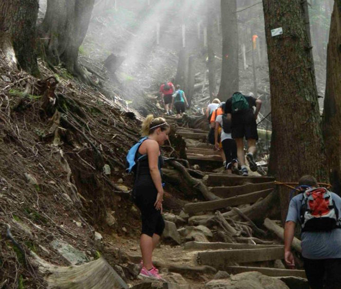
The rough and challenging Grouse Grind Trail. Photo credit: Vancouver’s North Shore Tourism
Lynn Loop
This classic North Shore hike is perfect for an overcast day since it’s entirely in the beautiful West Coast rainforest. The trail climbs up into the trees before looping back to descend along the banks of Lynn Creek. Use the Lynn Headwaters Regional Park map to find your way.
Trail Stats: Moderate / 160m elevation gain / 5km loop / 2 hours
Getting There: Take the 228 bus from Lonsdale Quay. Get off on Lynn Valley Road at Dempsey Road, then walk down Lynn Valley road into the park.
Killarney Lake
Bowen Island is easy to reach from Vancouver via bus and ferry, but it feels worlds away. You can walk right off the ferry onto the trail to Killarney Lake. The trail around the lake is easy and flat. Be sure to stop at the picnic areas and viewpoints to soak up the views. The trail network can be a bit confusing, but the Crippen Regional Park map will help.
Trail Stats: Easy / no elevation gain / 9km loop / 2.5 hours
Getting There: Take the 257 or 250 bus from downtown Vancouver to Horseshoe Bay, then take the Bowen Island ferry.
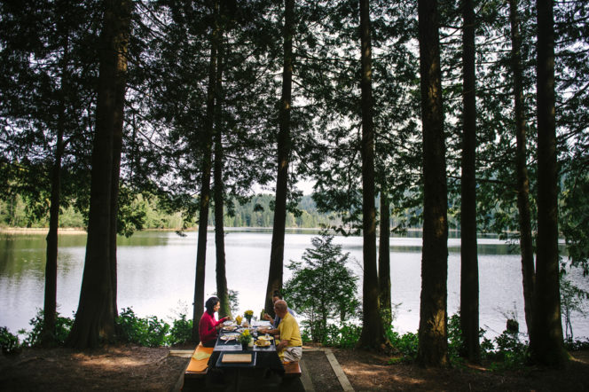
Picnicking at Killarney Lake on Bowen Island. Photo credit: Tourism Vancouver / Destination Canada (CTC)
Jug Island
Head out to Belcarra Regional Park to hike to a wilderness beach in the heart of Vancouver’s suburbs. You’ll walk through an impossibly green mossy forest, then emerge on the shores of Indian Arm at Jug Island. The communities of Belcarra and Deep Cove are nearby, but all you’ll see is nature. Keep yourself oriented with the park map.
Trail Stats: Moderate / 100m elevation gain / 5.5km return / 2 hours
Getting There: From Port Moody Skytrain station, take bus 182 to the Belcarra Park picnic area.


One Response to 5 Vancouver Hikes You Can Get to on Public Transit