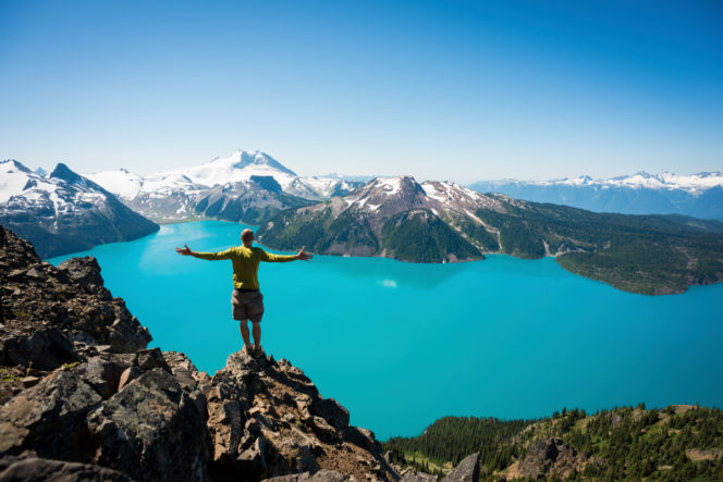
The view of Garibaldi Lake from Panorama Ridge. Photo credit: Tourism Whistler/Mike Crane
To get the best views, sometimes you have to sweat a little. (Or a lot!) These Vancouver-area trails are tough with super steep climbs and long distances. But they all have breath-taking views at the top that will make you forget all the effort it took to get there. Here are our picks for the most epic hikes around Vancouver.
Safety First
North Shore Rescue recommends bringing a backpack with essential safety and first aid gear on every hike. Check the forecast and pack extra clothing for the weather. And leave a trip plan so someone knows where you are going and when you will be back. Hiking is a little different during the pandemic. Read our tips for getting outdoors during COVID-19.
A word of caution: The hikes on this list are tough and best for experienced hikers only. Most of these trails are high in the mountains and will be too snowy to hike between mid-October and late June. If you are new to hiking, start with easier trails first, then work your way up to challenging trails like these. If you plan to tackle these hikes, get an early start, pack extra clothes, and bring lots of food and water.
Garibaldi Lake and Panorama Ridge
The gorgeous turquoise blue water of Garibaldi Lake in Garibaldi Provincial Park is a magnet for hikers. It’s a gorgeous spot, made even better by the snow-capped mountains around it. Hardy hikers can tackle the trail to the lake in 5 to 6 hours. It’s 18km return with 820m of elevation gain. But those with enough energy should continue to Panorama Ridge, an incredible viewpoint above the lake. Add on 6 more hours, 12 more kilometres, and 700 m more elevation gain for Panorama Ridge. Get directions. (Heads up: This hike currently requires a day pass.)
Al’s Habrich Ridge
Scramble across granite slabs (sometimes with the help of ropes) on Al’s Habrich Ridge Trail. This hike sits in the quiet backcountry above the Sea to Sky Gondola so it’s a good place to escape the crowds. You don’t need to make it to the top to enjoy incredible views – you can gaze down at Howe Sound from numerous viewpoints along the way. The trail is 7km round trip with 440m of elevation gain, so allow at least 5 hours. Get directions.
Hikers on the Al’s Habrich Ridge Trail. Photo credit: Sea to Sky Gondola
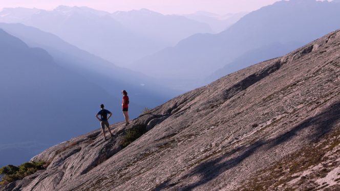
St. Mark’s Summit
The trail to St. Mark’s Summit in Cypress Provincial Park gets progressively rougher as you hike, with lots of roots and rocks underfoot. But the payoff is truly epic: you’ll finish on a rocky outcropping that seems to plunge straight down into Howe Sound. There are several viewpoints to explore, but be careful as the drop-offs are sheer. It’s an 11 km hike (round trip) with 480 m of elevation gain. Plan to spend about 5 hours. Get directions. (Heads up: This hike currently requires a day pass.)
Frosty Mountain
At 2408 m, Frosty Mountain is the tallest peak in E.C. Manning Provincial Park. It’s a long way to the rocky summit, but the views from the top are incredible. Plan your visit for autumn when the larch trees turn golden, lighting up the slopes. Allow 8 to 9 hours for the hike. It’s 22km round trip with 1160m of elevation gain. Get directions.
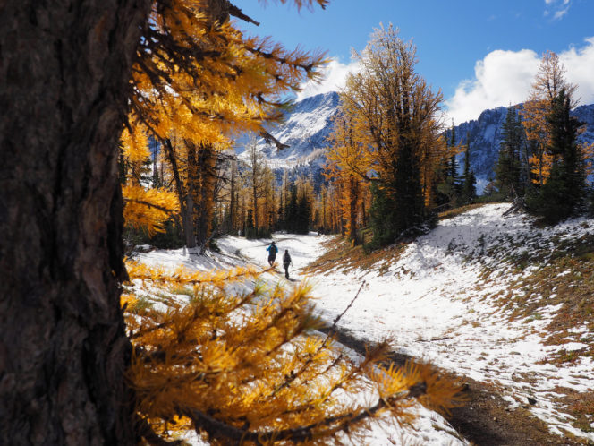
Walking through larches on the hike to Frosty Mountain. Photo credit: Destination BC/Gershon Dazon
The Lions
Also known as the twin sisters (Ch’ich’iyúy Elxwíkn in the Squamish language), the double peaks of the Lions dominate the North Shore Mountains. This very challenging hike climbs relentlessly from the village of Lions Bay to the base of the West Lion. The trail ends at a beautiful viewpoint over Howe Sound. (The route to the top is strictly for rock climbers only.) Allow at least 8 hours for the 16km round trip with 1280m of elevation gain. Get directions.
Elk Mountain
The tough trail to the top of Elk Mountain climbs steeply through the forest before emerging on a ridge. From the top, you get great views down to Chilliwack below you. To continue the adventure, follow the trail along the top of the ridge to the summit of nearby Mount Thurston. If you hike to Elk Mountain, give yourself 4 hours to hike the 7km round trip trail with 800m of elevation. The add-on to Mount Thurston is another 8km round trip with 200m more meters of elevation gain and will take another 4 hours. Get directions.
Stawamus Chief
If you’re afraid of heights, this hike in Stawamus Chief Provincial Park isn’t for you. It scrambles up rocks using stairs, ladders, and chains to reach the three summits of the Stawamus Chief, a huge granite face towering above Squamish. The trail is incredibly steep, so take your time going down to save your knees. The hike is 11km return with 600m of elevation gain. Plan to spend about 6 hours. Get directions. (Heads up: This hike currently requires a day pass.)
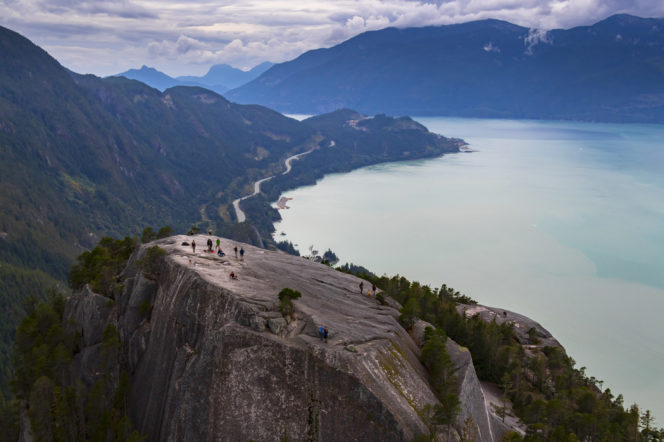
Hikers on the Stawamus Chief. Photo credit: Tourism Vancouver/Heath Moffatt


6 Responses to Epic Hikes Around Vancouver