Norvan Falls in Lynn Headwaters Regional Park in North Vancouver. Photo credit: Taryn Eyton, happiestoutdoors.ca
The hike to Norvan Falls in North Vancouver is a great choice for October. The entire trail is in the Lynn Creek Valley, making it an ideal trip for cloudy days. Your objective is 30-metre-tall Norvan Falls, which is often gushing at this time of year thanks to fall rains. While this hike is not short, it’s fairly flat so it is only moderately difficult.
Safety First: North Shore Rescue recommends bringing a backpack with essential safety and first aid gear on every hike. Check the forecast and pack extra clothing for the weather. Remember that it gets dark sooner at this time of year. Start your hike early and pack a flashlight just in case. And leave a trip plan so someone knows where you are going and when you will be back. Hiking is a little different during the pandemic. Read our tips for getting outdoors during COVID-19.
Trail Stats: 14 km return, 195 m elevation gain, 5 hours, moderate, dogs allowed off-leash
Getting There: This hike is in Lynn Headwaters Regional Park in North Vancouver. To get there, take exit 19 onto Lynn Valley Road from Highway 1. Follow Lynn Valley Road to its end inside Lynn Headwaters Park. The parking area closest to the trailhead fills fast, so you may need to park in one of the other parking areas along the road.
It is also possible to get to Lynn Headwaters Regional Park by public transit. Take the 210 bus from downtown Vancouver or Phibbs Exchange in North Vancouver. Get off at the Underwood Avenue at Evelyn Street stop. (Ask the bus driver for help.) Walk east through Evelyn Park to Lynn Valley Road. Turn left and walk down Lynn Valley Road to the trailhead about 20 minutes away. This adds about 1.6 km each way to your hike.
The Trail: The trails in Lynn Headwaters Regional Park are easy to follow, with signs at every junction so you shouldn’t have any trouble following the directions below. However, you may want to use some of the interconnected trail network to make your trip longer or take a different route back. Bring a copy of the Lynn Headwaters Regional Park Map to plan your hike.
The trail starts at the farthest parking lot. Follow the gravel path past the historic Cedar Mills House and some outhouses, then across Lynn Creek on a large bridge. On the other side, reach a large signboard. Turn left to go past a gate onto the Lynn Loop Trail.
Follow this trail as it parallels Lynn Creek on a wide and flat gravel trail. You’ll get a glimpse of the water through the trees in a few places, but mostly you’ll be walking through beautiful coastal forest.
About 1.8km from the bridge, reach a junction where the Lynn Loop Trail heads uphill to the right. Continue straight on the Cedar Mills Trail alongside Lynn Creek. From this point, the trail gets a narrower and a little rougher with sections of stairs, boardwalks, rocks, and mud puddles.
The trail will emerge from the forest into an open rocky area about 4km from the trailhead. This place is called the Third Debris Chute since occasionally big storms wash gravel and boulders downhill here. Follow the path through the gravel to the right and slightly uphill to a junction with the Headwaters Trail.

Hikers on the trail to Norvan Falls. Photo credit: Taryn Eyton
Turn left and take the Headwaters Trail, continuing upstream through the forest. In this section, you’ll be high above Lynn Creek and won’t see it. Your route follows an old logging road. If you look carefully, you can spot old logging relics such as metal buckets and cables alongside the trail. The trail has patches of old skid road as well – sections where logs were laid along the ground to act as a road surface. Take care as they can be very slippery.
Three kilometres after leaving the Third Debris Chute, you’ll start to hear rushing water. Pass by a sign for the Coliseum Mountain Trail, then almost immediately afterwards, turn right onto a spur trail to the falls. (If you reach a metal suspension bridge over the creek, you’ve gone too far.)
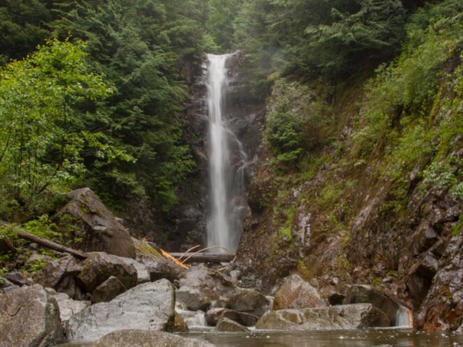
Climb steeply uphill on the spur trail for a few minutes before arriving at Norvan Falls. For the best views, you can clamber down the bank into the stream bed or follow the trail uphill to a small viewpoint.

A view of Norvan Falls from the stream bed. Photo credit: Taryn Eyton
After you’ve enjoyed the waterfall, retrace your steps back to the parking lot. You can also vary your route by taking the upper portions of the Headwaters and Lynn Loop Trails back to the trailhead. These trails are rougher and slightly longer so make sure you have enough time and energy.


