Photo: West Vancouver Parks and Recreation
West Vancouver’s Cypress Falls Park features a beautiful canyon and two spectacular waterfalls. Spring is the perfect time to hike here, as the melting snow turns the waterfalls into torrents. It’s a short and easy hike, perfect for hikers of all ages.
Until further notice, in line with the public health order, non-essential travel into, within, and out of BC is not recommended. BC residents, let’s do our part by continuing to stay small and support local with your immediate household, in accordance with the latest guidelines.
Safety First: AdventureSmart recommends bringing a backpack with essential safety and first aid gear on every hike. Check the forecast and pack extra clothing for the weather. Leave a trip plan so someone knows where you are going and when you will be back. Hiking is a little different during the pandemic. Read our tips for getting outdoors during COVID-19.
Trail Stats: Easy, 2.5km return, 100m elevation gain, 1-1.5 hours, dogs allowed off-leash
Getting There by Car: From Vancouver head over the Lions Gate or Ironworker’s Memorial Bridges and go west on Highway 1. Take exit 4 for Woodgreen Drive. From the off-ramp, turn right onto Woodgreen Drive. Follow it around the corner and up the hill, then turn right onto Woodgreen Place, following the sign for Cypress Falls Park. The street dead-ends at the park where there are two parking lots.
Getting There by Bus: Take bus 250 or 250A to West Vancouver from Georgia and Burrard in downtown Vancouver. Get off at Park Royal, then switch to bus 253. Get off on Woodgreen Drive at Woodgreen Place. Walk one block down Woodgreen Place to reach the park.
The Trail: This hike follows the banks of Cypress Creek to reach two waterfalls. The lower falls are a short and easy walk from the parking lot. To reach the upper falls, you’ll need to climb up a steep hill.
There are many trails in Cypress Falls Park, and most of them do not have signs. However, if you stick to the widest trails and follow the directions below, you won’t get lost.
From the far end of the parking lot above the baseball field, follow the trail into the forest. Within a few minutes, ignore a trail branching downhill to the right. It also goes to the lower falls, but walking on the upper trail is easier since it is wider.
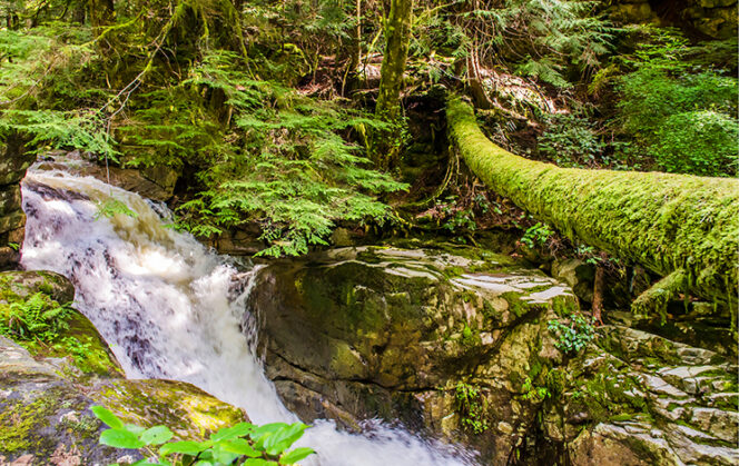
Soon you will reach Lower Cypress Falls. There are two viewing areas: behind a fence by the main trail and from a platform at the top of the falls. The best view of the falls is from the fence since you can see the entire falls as they plummet into the canyon. Stay behind the fences at both viewpoints as the drop-offs are deadly.
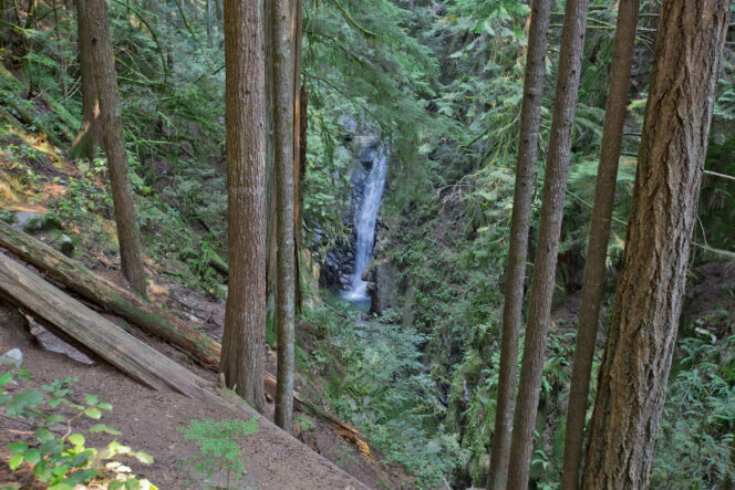
Lower Falls Viewpoint. Photo: West Vancouver Parks and Recreation
If you’re with small children or just want a short walk, turn around and retrace your steps to the car. But if you’re up for a slightly longer walk, you can continue to the Upper Falls.
From the viewing platform, continue along the trail to a bridge over the creek. Instead of crossing the bridge, stay on the left side of the creek and hike uphill along the banks of the canyon. There are several trails in this area. Stay on the main trail near the canyon.
The trail is steep in places, but never too rough. Pass through a gate in a chain-link fence and continue along the trail uphill. As you approach the viewing area, the roar of the water will get louder and louder. You have arrived at Upper Cypress Falls. There are no fences here, so stay well back from the canyon edge as the cliff can crumble away.
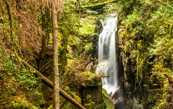
Upper Cypress Falls. Photo: GoToVan/Flickr used under CC BY 2.0.
When you have finished enjoying the falls, retrace your steps back to the parking lot. Pay attention at the many intersections to stay on the main trail.


