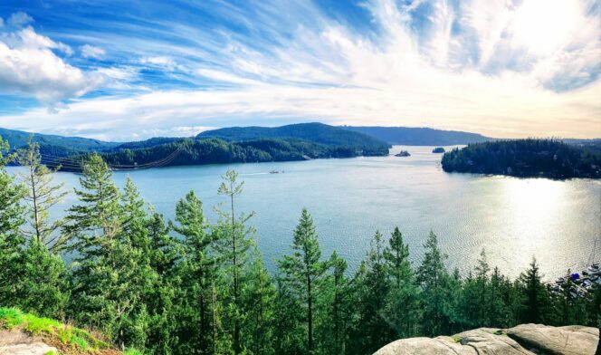
View from Quarry Rock. Photo: San/Unsplash
Quarry Rock in North Vancouver’s Deep Cove neighbourhood takes you through beautiful coastal rainforest to a spectacular viewpoint on a rocky outcrop. Fall is a great time to hike here since the summer crowds have died down.
Trail Info: Easy; 4 km round-trip; 100 metres elevation gain; 1.5 hours; Dogs permitted on-leash.
Safety First: AdventureSmart recommends bringing a backpack with essential safety and first aid gear on every hike. Check the forecast and pack extra clothing for the weather. Leave a trip plan so someone knows where you are going and when you will be back. Check out our tips for safe fall hiking in Vancouver for more advice.
Getting There by Bus: Taking the bus is the easiest way to get to Quarry Rock. Catch the 211 bus from Burrard Station in downtown Vancouver or the 212 bus from Phibbs Exchange in North Vancouver. Get off on Panorama Drive in Deep Cove.
Getting There By Car: While you can get to the Quarry Rock trailhead by car, parking is very limited, so driving is not recommended. If you must drive, start by taking Highway 1 north over the Ironworkers Memorial Bridge to North Vancouver. Take exit 22B onto Mount Seymour Parkway. Stay on this road for 5.5 km, then turn left onto Deep Cove Road. Turn left a few minutes later on Panorama Drive, then immediately right into the parking lot at Panorama Park. This lot fills fast on sunny weekends and most other parking in Deep Cove is for residents only. You can find information about alternative parking locations on the District of North Vancouver website.
The Trail: The Quarry Rock Trail suffered a lot of damage in the 2021 storm and was closed for repairs until spring 2023. The trail has lots of new stairs, bridges, and signs, so it is easy to follow. The route to Quarry Rock is part of the much longer Baden Powell Trail that stretches for 48 km across the North Shore. Look for blue and orange fleur-de-lis trail markers as you hike, the symbol for the Baden Powell Trail.
To find the trailhead, follow Panorama Drive north away from Deep Cove Village. At the crosswalk at the far end of Panorama Park, watch for signs directing you left up the hill to the trailhead between two houses. The trail actually starts right next to someone’s driveway.
The first part of the trail heads straight uphill, gaining 70 meters right away. This section used to be very rooty, but new stairs have smoothed the path. After the initial climb, the trail swings right and levels out. The remainder of the trail looks fairly flat on maps, but that is deceptive as you have many small hills to climb and descend as you go in and out of creek gullies.
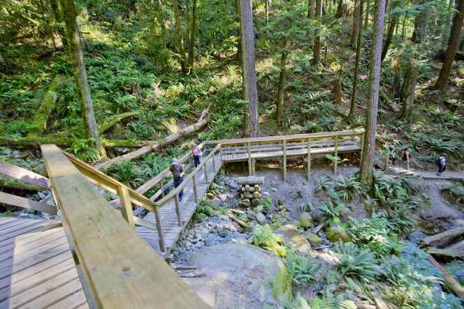
There are lots of bridges and stairs through the forest. Photo: GoToVan/Flickr used under CC BY 2.0
About 20 minutes from the start, cross a large wooden bridge over Cove Creek. Look for a huge old-growth Douglas fir tree on your right. Continue along the trail as it climbs and dips through the forest.
Descend to cross another bridge over Francis Creek, then immediately climb a small hill. Ignore two trails going left up the hill towards Indian River Drive. Instead, stay right and continue towards Quarry Rock. The forest opens up as you reach the rock outcropping.
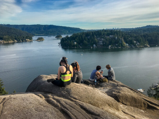
Enjoying the view at Quarry Rock. Photo: Taryn Eyton
Take a few minutes to enjoy the view of Indian Arm and Deep Cove. You can also see Belcarra across the water. Be careful on the rocks as there are sheer cliffs. When you are ready, retrace your steps back to the start of the hike.


