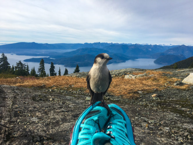
A curious whiskey jack on top of Mount Strachan. Please don’t feed them as it’s not good for their diet. (And they’ll come pose for you even without food.)
The hike to Mount Strachan in Cypress Provincial Park is a bit of a hidden gem. The open summit has great views of Howe Sound and the Lions. And in September, the alpine meadows shift from green to golden orange. There’s also an interesting Cold War-era plane crash to check out along the way. The rocky trail to the summit is moderately challenging, and often poorly marked, so it’s not a hike for beginners.
Safety First: Just because this hike is close to Vancouver doesn’t mean you aren’t going to the wilderness. North Shore Rescue recommends bringing a backpack with essential safety and first aid gear on every hike. Check the forecast and pack extra clothing for the weather. And leave a trip plan so someone knows where you are going and when you will be back.
If you’ve ever skied at Cypress Mountain in West Vancouver, chances are that you’ve been up Mount Strachan. The Sky Chair goes almost to the summit. But it also makes a great hike in summer and fall before the winter rains and snows arrive.

The view of Howe Sound and Bowen Island from Mount Strachan
The hike begins from the downhill ski parking lot at Cypress Mountain. There is a large map board in the parking lot near the Vancouver 2010 pillar. Start your hike here following a gravel access road behind the map board towards the ski runs. Look for the Baden Powell trail leaving the ski run to your right after about 100 meters.
Follow the Baden Powell trail through the forest for about 30 minutes until you come to a ruined bridge in a steep gully. Just before the bridge, you should see a trail heading uphill to your left. This is the Old Mount Strachan Trail. Follow this trail as it climbs through the forest. There are a few markers, but in some places, the trail can be hard to spot. As you continue on the Mount Strachan trail, you’ll reach a swampy area and then a gully. Stay left at a faint junction.
After the gully, the trail climbs up into a more open forest near the ski runs. Soon you’ll reach the remains of a Royal Canadian Navy T-33 jet that crashed during a training run in 1963. There is a plaque nearby in memory of the soldiers who lost their lives here. Please be respectful of this area and leave all the debris where you find it.

T-33 crash debris site. Photo credit: Su-Laine Yeo Brodsky on Flickr. Used under CC BY-SA 2.0
Continuing past the crash site, the trail meanders through more open forest before emerging in a subalpine meadow near the chairlift. This is the best area to spot fall colourrs on the hike. The trail gets steeper in this area as it climbs over a few rocky areas to reach the south summit of Mount Strachan at 1445m. The open rock slabs of the summit have great views of Howe Sound.
Once you’ve enjoyed the vistas, continue north along the summit ridge and descend into a small gully. Scramble up the other side to reach the higher north summit at 1459m. The view of the Lions from here is incredible!

The Lions from Mount Strachan
To head back to your car, retrace your steps to the south summit, then follow the trail back down the way you came. An alternative option is to walk the ski runs back down, saving about 1 kilometre of walking. For this option, continue along the rock slab south past the Mount Strachan trail to the top of the Sky Chair. Follow the T-33 ski run down from the Sky Chair to the top of the Lions Chair. From here, follow the Collins ski run all the way back to the parking lot.
Trail stats: 10.5km return, 550m elevation gain, 5 hours.


One Response to September’s Vancouver Hike of the Month: Mount Strachan