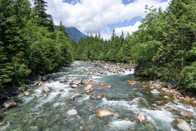
Gold Creek from the bridge. Photo: Taryn Eyton, HappiestOutdoors.ca
With snow blanketing the mountain tops, November is a great time for low-elevation valley bottom hikes. This loop route in Golden Ears Provincial Park is a great hike for a wet or cloudy day. It travels through lush forest along the banks of Gold Creek and passes by a beautiful waterfall.
Safety First: AdventureSmart recommends bringing a backpack with essential safety and first aid gear on every hike. Check the forecast and pack extra clothing for the weather. Leave a trip plan so someone knows where you are going and when you will be back. Hiking is a little different during the pandemic. Read our tips for getting outdoors during COVID-19.
Trail Stats: 12 km loop, 185 m elevation gain, 4 hours, moderate difficulty, dogs allowed on-leash
Getting There: This hike is in Golden Ears Provincial Park in Maple Ridge. To get there take Highway 1 east from Vancouver over the Port Mann Bridge. Leave the highway at Exit 53 and follow the signs to turn left onto Golden Ears Way. Continue on Golden Ears Way across the Golden Ears Bridge into Maple Ridge where it becomes 128 Avenue, then Abernethy Way.
Turn left on 232 Street and follow it north. Go right at the roundabout onto 132 Avenue. Follow it as it becomes Fern Crescent and then enters Golden Ears Provincial Park. Continue through the park on the main road for 13km to a bridge. Cross the bridge, then turn left into the Gold Creek parking lot.
Heads up: The park gate at Golden Ears Provincial Park is unlocked from 8:00 a.m. until 5:30 p.m. in the winter. If there is snow or ice on the road, the park will be closed.

Forested trail. Photo: Priscilla du Preez on Unsplash.
The Trail: This hike uses several trails to make a circuit in the Gold Creek Canyon. Most junctions are well signed, but bring a copy of the Golden Ears park map to help orient yourself.
From the parking lot, follow the wide and easy Lower Falls Trail beside Gold Creek. After 2.5 km reach Gold Creek Falls. You can admire the Lower Falls from the viewpoint here, or follow a faint and very rough trail a few minutes upstream to see Upper Falls.
After you have enjoyed the waterfall, turn right and head steeply uphill on the Connector Trail. You will gain about 80 m of elevation in less than half a kilometre. After the stiff climb, emerge from the forest on the wide East Canyon Trail, a former road.
Turn left to follow it upstream for about a kilometre to another junction. The trail to your left descends to cross Gold Creek on a bridge. This is your return route. But before heading back to the trailhead, continue straight on the East Canyon Trail for a few more minutes to an outhouse and a spur trail heading left. Follow it down to Viewpoint Beach on Gold Creek, which is a great place to have lunch. On a clear day, there are great views of Golden Ears Peak.
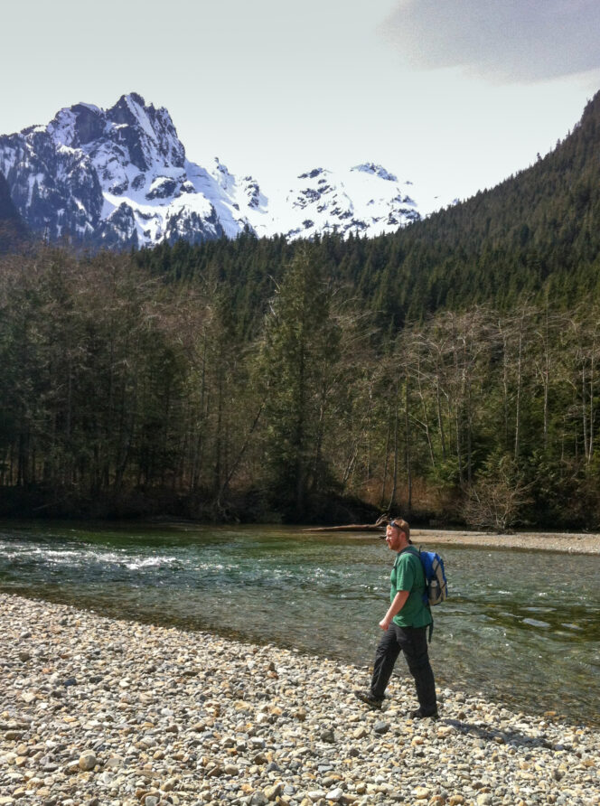
Golden Ears Peak from Viewpoint Beach. Photo: Taryn Eyton, happiestoutdoors.ca
When you are ready to continue hiking, retrace your steps back to the East Canyon Trail, turn right and head back to the junction. Turn right again and follow the trail to the bridge. Soak up the beautiful views of the canyon from the bridge, then head through the forest to another junction. Turn left and hike uphill to begin your return journey down the west side of the valley.
A few minutes later, arrive at another junction. The long and challenging route to the summit of Golden Ears heads right while you go left on the West Canyon Trail. The next section of trail is rough, rooty, and rocky. Pause at the signed Gold Creek Lookout to gaze down to the bridge far below you.
About 10 minutes after the lookout, the rough trail ends and an old eroded gravel road begins. A sign here points the way down the steep slope to the left to an alternative view of Lower Falls. It’s a very steep trail, but it’s short and is worth it if you have the extra energy.
Back on the main trail, follow the old road for about 3 kilometres passing through beautiful mossy forest and across several rushing creeks. Ignore the turn-off to the Viewpoint Point Trail on your right, and continue for a few minutes to intersect the Menzies Trail. Turn left to follow it downhill to the park road. Turn left and follow the road across the bridge and into the Gold Creek parking lot where you started.


